November 30, 2024, 05:41:17 AM

Show Posts

This section allows you to view all posts made by this member. Note that you can only see posts made in areas you currently have access to.


Messages - Mr. Rainman

Pages: 1 ... 88 89 [90] 91 92 ... 94
1336
General Discussion / Re: Election Day Discussion & Coverage
« on: November 02, 2010, 08:09:19 AM »
Eh, no indiciment, I believe. He's just been living with his parents and for some reason, the Democrats nominated him. It really pissed off the National Democratic Committee, who tried to get the guy off the ballot, but he's staying in (essentially guarenteeing a Republican Senator).

1337
Hurricane Central / Re: Hurricane Tomas
« on: November 01, 2010, 06:52:19 PM »
Tomas has substantially weakened back to a disorganized tropical storm, with winds of 45 mph. It looks like the U.S. won't being seeing any major effects from this storm. Haiti, however, is dead in Tomas's path.

The storm is forecast to become a hurricane again with sustained winds of 90 mph before making landfall. When it leaves the island, winds are expected to have died down to 80 mph.

There are only 29 days left in the hurricane season, which is plenty of time for three more storms to form. My percentage chance of Tropical Storm Alpha forming before season's end: 70%.

EDIT: Significant Wave Heights near Tomas's center are between 15-20 feet. Ocean temperatures in storm's path are between 84-87 degrees.

1338
General Discussion / Re: Election Day Discussion & Coverage
« on: November 01, 2010, 06:45:42 PM »
I don't turn 18 until the 20th, and I wish I could vote in the South Carolina governer's race. The battle Jim DeMint and the no-name, no-political background Democrat? Well, you can probably guess who's winning that one.

1339
General Weather Chat / Re: Severe Weather Threat: Tuesday, October 26th
« on: October 28, 2010, 09:12:37 PM »
Oh, and here is the AMAZING satellite image of this storm. Isn't it impressive?  :blink:


1340
General Weather Chat / Re: Severe Weather Threat: Tuesday, October 26th
« on: October 28, 2010, 09:10:59 PM »
Well, according to the SPC, the system has moved off and a high pressure system has taken its place. It looks like the majority of the nation is in for a beautiful weekend.

To close this out, here are a list of storm reports from the monster system, which I am officially dubbing "The Great Derecho of 2010."

- 2 injured in a EF1 tornado that touched down in Kenosha County, WI.
- Wanatah, IN, experienced an EF1 tornado with estimated winds fo 85-90 mph.
- Buckland, OH, showed damage caused by a possible EF2.
- EF2 tornado damaged dam in Chattanooga, TN ( :thrilled:, for some odd reason).
- Possible EF2 tornado in Dekalb County, AL.
- 1.75 inch hail reported in Cleveland, GA.
- Butlerville, OH, reported 81 mph winds.
- 80 mph winds reported in Greenfield, IN.


1341
General Weather Chat / Re: Severe Weather Threat: Tuesday, October 26th
« on: October 26, 2010, 08:24:33 PM »
Holy crap, tornado spotted near Chattanooga. The sky looks AWESOME!

1342
General Weather Chat / Re: Severe Weather Threat: Tuesday, October 26th
« on: October 26, 2010, 11:26:01 AM »
A Particulary Dangerous Situation Tornado Watch is in effect. This is very, VERY close to Chattanooga. I'm literaly shaking a little as I type this.


Quote
THE NWS STORM PREDICTION CENTER HAS ISSUED A
   TORNADO WATCH FOR PORTIONS OF
   
          NORTHERN ALABAMA
          MIDDLE TENNESSEE
   
   EFFECTIVE THIS TUESDAY MORNING AND AFTERNOON FROM 930 AM UNTIL
   500 PM CDT.
   
   ...THIS IS A PARTICULARLY DANGEROUS SITUATION...
   
   DESTRUCTIVE TORNADOES...LARGE HAIL TO 1.5 INCHES IN DIAMETER...
   THUNDERSTORM WIND GUSTS TO 70 MPH...AND DANGEROUS LIGHTNING ARE
   POSSIBLE IN THESE AREAS.
   
   THE TORNADO WATCH AREA IS APPROXIMATELY ALONG AND 85 STATUTE
   MILES EAST AND WEST OF A LINE FROM 60 MILES NORTHEAST OF
   NASHVILLE TENNESSEE TO 55 MILES SOUTHEAST OF TUPELO MISSISSIPPI.
   FOR A COMPLETE DEPICTION OF THE WATCH SEE THE ASSOCIATED WATCH
   OUTLINE UPDATE (WOUS64 KWNS WOU3).
   
   REMEMBER...A TORNADO WATCH MEANS CONDITIONS ARE FAVORABLE FOR
   TORNADOES AND SEVERE THUNDERSTORMS IN AND CLOSE TO THE WATCH
   AREA. PERSONS IN THESE AREAS SHOULD BE ON THE LOOKOUT FOR
   THREATENING WEATHER CONDITIONS AND LISTEN FOR LATER STATEMENTS
   AND POSSIBLE WARNINGS.
   
   OTHER WATCH INFORMATION...CONTINUE...WW 720...WW 721...WW 722...
   
   DISCUSSION...A PRE-FRONTAL BAND OF CONVECTION CURRENTLY DEEPENING
   FROM N-CNTRL MS NWD TO E OF MKL IS EXPECTED TO EVOLVE INTO TSTMS
   LATE THIS MORNING WITHIN A STRONGLY SHEARED AND
   WARMING/DESTABILIZING ENVIRONMENT.  THE COMBINATION OF EFFECTIVE SRH
   OF 300-400 M2/S2...MLCAPE OF 500-1000 J/KG AND THE POTENTIAL FOR
   MORE DISCRETE STORM MODES SUGGEST A THREAT LONG-TRACKED SUPERCELLS
   CAPABLE OF STRONG TORNADOES.

1343
General Weather Chat / Re: Severe Weather Threat: Tuesday, October 26th
« on: October 26, 2010, 08:04:44 AM »
A high risk day indicates a considerable likelihood of a major tornado outbreak or (much less often) an extreme derecho event. On these days, the potential exists for extremely severe and life-threatening weather, including widespread strong or violent tornadoes and/or very destructive straight-line winds (Hail cannot verify or produce a high risk on its own, although such a day usually involves a threat for widespread very large hail as well). Many of the most prolific severe weather days were high risk days. Such days are quite rare; a high risk is typically issued only a few times each year (see List of SPC High Risk days). High risk areas are usually surrounded by a larger moderate risk area, where uncertainty is greater or the threat is somewhat lower.[9]


1344
General Weather Chat / Re: Severe Weather Threat: Tuesday, October 26th
« on: October 26, 2010, 08:02:38 AM »
And finally, the Public Severe Weather Outlook and a definition from Wikipedia:

Quote
...SEVERE THUNDERSTORMS EXPECTED OVER PARTS OF THE OHIO AND
   TENNESSEE VALLEYS AND GREAT LAKES...
   
   THE NWS STORM PREDICTION CENTER IN NORMAN OK IS FORECASTING THE
   DEVELOPMENT OF WIDESPREAD DAMAGING WINDS AND A FEW TORNADOES OVER
   PARTS OF THE OHIO AND TENNESSEE VALLEYS AND GREAT LAKES TODAY
   THROUGH EARLY WEDNESDAY
   
   THE AREAS MOST LIKELY TO EXPERIENCE THIS ACTIVITY INCLUDE
   
          EASTERN ILLINOIS
          INDIANA
          NORTHERN KENTUCKY
          SOUTHERN MICHIGAN
          WESTERN AND CENTRAL OHIO
   
   ELSEWHERE...SEVERE STORMS ALSO ARE POSSIBLE FROM THE LOWER
   MISSISSIPPI VALLEY NORTHEASTWARD INTO THE APPALACHIANS AND LOWER
   GREAT LAKES
   
   A POWERFUL JET STREAM DISTURBANCE...WITH WINDS IN EXCESS OF 175
   MILES PER HOUR...WILL MOVE FROM THE CENTRAL ROCKIES ACROSS THE
   CENTRAL PLAINS INTO OHIO VALLEY LATER TODAY AND TONIGHT.
   
   AT THE SAME TIME...AN INTENSE SURFACE LOW ASSOCIATED WITH THE JET
   WILL FURTHER STRENGTHEN AS IT TRACKS SLOWLY NORTHEAST FROM MINNESOTA
   INTO WESTERN ONTARIO.
   
   A COLD FRONT TRAILING SOUTH FROM THE LOW WILL SERVE AS THE MAIN
   FOCUS FOR THUNDERSTORM DEVELOPMENT THROUGH EARLY WEDNESDAY AS THE
   FRONT ACCELERATES EAST ACROSS THE OHIO AND TENNESSEE VALLEYS
   TODAY...AND ACROSS THE LOWER GREAT LAKES AND THE APPALACHIANS
   TONIGHT/EARLY WEDNESDAY.
   
   THE VERY STRONG WINDS ASSOCIATED WITH THE LOW...AND INCREASING
   MOISTURE SPREADING RAPIDLY NORTH FROM THE GULF COAST STATES...WILL
   ALLOW THE THUNDERSTORMS TO ORGANIZE INTO BANDS THAT WILL BE CAPABLE
   OF PRODUCING SWATHS OF DAMAGING WIND AND A FEW STRONG TORNADOES.
   
   WHILE THE GREATEST RISK OF SEVERE WEATHER IS EXPECTED TO OCCUR
   DURING THE DAY TODAY OVER THE OH AND TENNESSEE VALLEYS...A MORE
   LIMITED THREAT FOR HIGH WIND AND ISOLATED TORNADOES WILL CONTINUE
   THROUGH EARLY WEDNESDAY EASTWARD INTO THE APPALACHIANS AND THE LOWER
   GREAT LAKES.
   
   STATE AND LOCAL EMERGENCY MANAGERS ARE MONITORING THIS POTENTIALLY
   VERY DANGEROUS SITUATION. THOSE IN THE THREATENED AREA ARE URGED TO
   REVIEW SEVERE WEATHER SAFETY RULES AND TO LISTEN TO
   RADIO...TELEVISION...AND NOAA WEATHER RADIO FOR POSSIBLE
   WATCHES...WARNINGS...AND STATEMENTS LATER TODAY.

1345
General Weather Chat / Re: Severe Weather Threat: Tuesday, October 26th
« on: October 26, 2010, 08:01:31 AM »
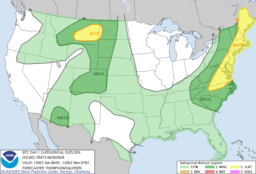
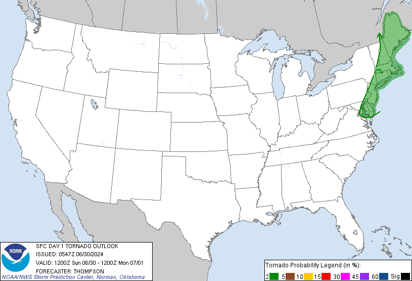
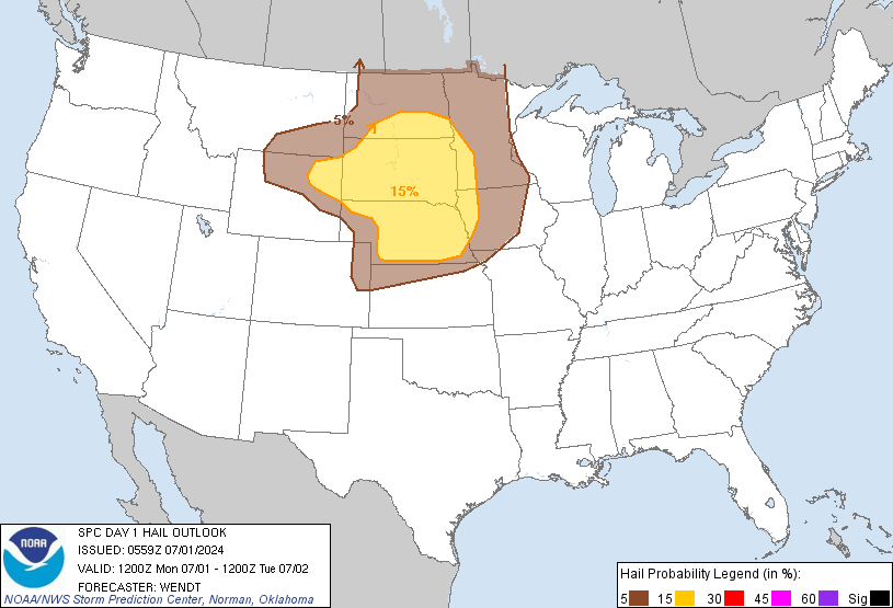
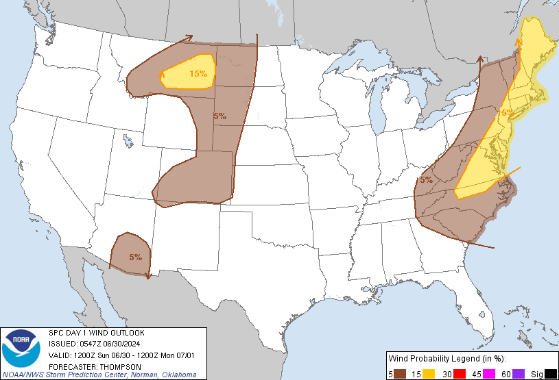
The risk for severe thunderstorms has significantly increased over the last couple of hours. A very rare High Risk day is in effect. Here is the convective outlook.


The chance of tornadoes:


The chance of hail:


And the chance of wind:


1346
General Discussion / Re: The Pot Belly Stove
« on: October 26, 2010, 07:53:11 AM »
On a weather-related note:

The Storm Prediction Center has issued a High Risk Convective Outlook for most of today. This means that extremely dangerous storms are likely to occur. High Risk days are extremely rare this time of the year, and when one has occured, massive severe weather outbreaks have ripped across the U.S. (The Super Tuesday Outbreak, for example).

This is a very dangerous weather event. Anyone who wants or needs to discuss it should head to the thread posted a few posts above this one. It is called "Severe Weather Threat: Tuesday, October 26th." Updates to the thread will be posted periodically.

Stay safe out there, members. Today is gonna be a doozy.

1347
Forecasting / Re: Ask The Weather Expert!
« on: October 25, 2010, 11:26:39 PM »
Patrick, The Weather Channel just used a term called "bombogenesis," a word I can barely understand, let alone pronounce. What, exactly, is bombogenesis?

1348
General Weather Chat / Re: Severe Weather Threat: Tuesday, October 25th
« on: October 25, 2010, 11:10:53 PM »
Tornado Watch 719 has been issued. Here is all the counties it covers. In effect until 6:00 AM CDT.


Tornadoes and highly severe wind are the primary threats.

1349
General Weather Chat / Re: Severe Weather Threat: Tuesday, October 25th
« on: October 25, 2010, 09:18:18 PM »
URGENT UPDATE: SEVERE WEATHER THREAT FOR TONIGHT.


Mainly a wind threat.


All of this severe weather is being triggered by a massive low pressure system with estimated barometric pressures of 960-970 mb (28.35 - 28.65 inches) near its center in Canada. High winds and very severe storms will affect the Northern Plains Tuesday afternoon, and by Tuesday night, several inches of snow and even blizzard-like conditions will exist in North Dakota. This storm, as the Weather Channel puts it, could be the biggest fall storm in 10 to 20 years.

1350
General Discussion / Re: The Pot Belly Stove
« on: October 25, 2010, 09:15:16 PM »
I understand that completely, Patrick. Everytime I come across something like circular motion, I tell myself that. I'll need physics, alright, but I don't have to like it.

Pages: 1 ... 88 89 [90] 91 92 ... 94