5806
Local Forecast / Re: What lf songs do you wish to have?
« on: April 12, 2009, 03:17:40 PM »
Chris Camozzi - Curves
This section allows you to view all posts made by this member. Note that you can only see posts made in areas you currently have access to.

What does TWC do if they have to take cover? Do they have storm safe studios?


URGENT - IMMEDIATE BROADCAST REQUESTED
TORNADO WATCH NUMBER 134
NWS STORM PREDICTION CENTER NORMAN OK
340 PM EDT FRI APR 10 2009
THE NWS STORM PREDICTION CENTER HAS ISSUED A
TORNADO WATCH FOR PORTIONS OF
CENTRAL AND EASTERN ALABAMA
NORTHERN GEORGIA
FAR WESTERN NORTH CAROLINA
EFFECTIVE THIS FRIDAY AFTERNOON AND EVENING FROM 340 PM UNTIL
1000 PM EDT.
...THIS IS A PARTICULARLY DANGEROUS SITUATION...
DESTRUCTIVE TORNADOES...LARGE HAIL TO 3 INCHES IN DIAMETER...
THUNDERSTORM WIND GUSTS TO 70 MPH...AND DANGEROUS LIGHTNING ARE
POSSIBLE IN THESE AREAS.
THE TORNADO WATCH AREA IS APPROXIMATELY ALONG AND 70 STATUTE
MILES EAST AND WEST OF A LINE FROM 55 MILES WEST NORTHWEST OF
ASHEVILLE NORTH CAROLINA TO 30 MILES SOUTHEAST OF ANNISTON
ALABAMA. FOR A COMPLETE DEPICTION OF THE WATCH SEE THE
ASSOCIATED WATCH OUTLINE UPDATE (WOUS64 KWNS WOU4).
REMEMBER...A TORNADO WATCH MEANS CONDITIONS ARE FAVORABLE FOR
TORNADOES AND SEVERE THUNDERSTORMS IN AND CLOSE TO THE WATCH
AREA. PERSONS IN THESE AREAS SHOULD BE ON THE LOOKOUT FOR
THREATENING WEATHER CONDITIONS AND LISTEN FOR LATER STATEMENTS
AND POSSIBLE WARNINGS.
OTHER WATCH INFORMATION...CONTINUE...WW 131...WW 132...WW 133...
DISCUSSION...INTENSE MID/UPPER LEVEL SYSTEM AND ASSOCIATED JETS WILL
CONTINUE TO FOCUS OUTBREAK OF SUPERCELLS EWD ACROSS WW THIS EVENING.
VERY FAVORABLE ENVIRONMENT IN PLACE FOR LARGE...DAMAGING HAIL ALONG
WITH POTENTIAL FOR LONG-TRACKED/DAMAGING TORNADOES. TORNADO THREAT
WILL BE ENHANCED ALONG AND SOUTH OF WEDGE SURFACE FRONT OVER GA/AL
COUNTIES WITHIN WW.
AVIATION...TORNADOES AND A FEW SEVERE THUNDERSTORMS WITH HAIL
SURFACE AND ALOFT TO 3 INCHES. EXTREME TURBULENCE AND SURFACE
WIND GUSTS TO 60 KNOTS. A FEW CUMULONIMBI WITH MAXIMUM TOPS TO
500. MEAN STORM MOTION VECTOR 25040.
...EVANS

URGENT - IMMEDIATE BROADCAST REQUESTED
TORNADO WATCH NUMBER 131
NWS STORM PREDICTION CENTER NORMAN OK
855 AM CDT FRI APR 10 2009
THE NWS STORM PREDICTION CENTER HAS ISSUED A
TORNADO WATCH FOR PORTIONS OF
WESTERN KENTUCKY
WESTERN AND MIDDLE TENNESSEE
EFFECTIVE THIS FRIDAY MORNING AND AFTERNOON FROM 855 AM UNTIL 400
PM CDT.
TORNADOES...HAIL TO 3 INCHES IN DIAMETER...THUNDERSTORM WIND
GUSTS TO 80 MPH...AND DANGEROUS LIGHTNING ARE POSSIBLE IN THESE
AREAS.
THE TORNADO WATCH AREA IS APPROXIMATELY ALONG AND 105 STATUTE
MILES EAST AND WEST OF A LINE FROM 20 MILES NORTHWEST OF BOWLING
GREEN KENTUCKY TO 45 MILES SOUTH SOUTHEAST OF JACKSON TENNESSEE.
FOR A COMPLETE DEPICTION OF THE WATCH SEE THE ASSOCIATED WATCH
OUTLINE UPDATE (WOUS64 KWNS WOU1).
REMEMBER...A TORNADO WATCH MEANS CONDITIONS ARE FAVORABLE FOR
TORNADOES AND SEVERE THUNDERSTORMS IN AND CLOSE TO THE WATCH
AREA. PERSONS IN THESE AREAS SHOULD BE ON THE LOOKOUT FOR
THREATENING WEATHER CONDITIONS AND LISTEN FOR LATER STATEMENTS
AND POSSIBLE WARNINGS.
DISCUSSION...STRONG LOW PRESSURE WILL TRACK EAST TO THE LWR OH VLY
THROUGH THE DAY WITH COLD FRONT SWEEPING EWD ACROSS WRN/MIDDLE TN
AND WRN KY. STORMS ALREADY DEVELOPING AND INCREASING ALONG THE
ADVANCING COLD FRONT AND WILL MOVE INTO INCREASINGLY UNSTABLE
AIRMASS. VERY STRONG LOW LEVEL SHEAR IN PLACE ACROSS THE AREA OF THE
WATCH WITH MEMPHIS VWP INDICATING 70-75KT OF FLOW AT 2KM AGL.
THUS...EXPECT STORMS TO BECOME INCREASINGLY ORGANIZED WITH LINE
SEGMENTS AND SUPERCELLS MOVING AT OVER 40KT. TORNADO THREAT WILL
EXIST NEAR BREAKS IN THE LINE AND ALONG/NEAR RESIDUAL BOUNDARY/WARM
FRONT ACROSS SECTIONS OF WRN/MIDDLE TN NEXT FEW HOURS. VERY LARGE
HAIL AND HIGH WINDS ALSO LIKELY AS CONVECTION MATURES AND TAPS
GREATER INSTABILITY.
AVIATION...TORNADOES AND A FEW SEVERE THUNDERSTORMS WITH HAIL
SURFACE AND ALOFT TO 3 INCHES. EXTREME TURBULENCE AND SURFACE
WIND GUSTS TO 70 KNOTS. A FEW CUMULONIMBI WITH MAXIMUM TOPS TO
450. MEAN STORM MOTION VECTOR 26040.
...CARBIN
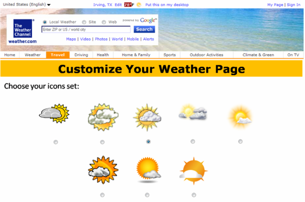
We know many of us can customized our weather.com page, but what if we get to choose which icons set to use? This idea comes from the Weather Underground website, where members get to customize their icons from there.
I've screencapped the weather.com website and made 3 different copies (the other 2 I cropped to buttons) and have blanked out the segment from the Navbar down. I then put 8 different versions of the "Partly Cloudy" icon and here's the end result:
DISCLAIMER:
All known materials are property of The Weather Channel and TWC Interactive. The 1st, 2nd, and 6th versions of the "Partly Cloudy" icon are property of TWC Classics and their creators Charles Abel and Nick Smith (see this and this). The 7th version of "Partly Cloudy" is property of NBC Universal, and the 8th version is property of its creator Raymie Humbert.