December 28, 2025, 03:28:19 PM

Show Posts

This section allows you to view all posts made by this member. Note that you can only see posts made in areas you currently have access to.


Messages - toxictwister00

Pages: 1 ... 206 207 [208] 209 210 ... 470
3106
Hurricane Central / Re: Hurricane Katia
« on: September 04, 2011, 08:54:57 PM »
I know annular hurricanes are rare, but doesn't it look like Katia could be one? She kinda seems to be getting that buzz saw look to her.

http://www.ssd.noaa.gov/goes/flt/t2/flash-vis.html

3107
Local Forecast / Re: Trammell Sightings
« on: September 04, 2011, 05:50:42 PM »
Briefly appeared at 5:49pm EDT.

3108
Hurricane Central / Re: Tropical Storm Lee
« on: September 04, 2011, 12:09:38 PM »
I find it sad and disturbing that while much of the Southeast is under a Flood Watch or Flood Warning of some sort, just a short hop west, you run into Texas coated in Red Flag warnings.

If there's any constellation to this, the GFS has been showing two more tropical storms developing in the GOM, one heading in the direction of S. TX and the other heading in the same direction of Lee. The downside is both are long range (7+ days out). Unfortunately, the reality is TX will continue to be shafted as long as that High pressure continues to linger around.

3109
Hurricane Central / Re: Hurricane Katia
« on: September 04, 2011, 11:31:11 AM »
Eye has popped out, looks rather large.

3110
Hurricane Central / Re: Tropical Storm Lee
« on: September 04, 2011, 11:09:42 AM »
Awesome rainband consolidating just to my SW heading my way! This is my first time being affected by a Tropical Storm since TS Claudette in 2009. I'm getting excited about our much needed rainfall and the Fall weather to follow.  :D

Looks like according to Dr. Forbes and our NWS office in Peachtree City agrees North Georgia will have a chance of seeing severe weather in the form of tornadoes on Monday. Dr. Forbes is giving North and West GA a 5/10 on his TORCON Index. We are also currently under a Flash Flood Watch until Tuesday.


3111
Hurricane Central / Re: Hurricane Katia
« on: September 04, 2011, 10:59:18 AM »
WOW.  :blink: Talk about a Rapid Intensification episode. Katia just went from a 75 mph Category 1 hurricane to a Category 2 with winds of 100 mph. NHC is forecasting a major hurricane by tomorrow.

A buoy reported a wind gust of 90mph on the NE side not long after the 8am advisory. :o If Katia had of been close enough for them to fly into and investigate, she probably would have been upgraded to a Cat. 2 during the 8am advisory instead.

3112
OCMs & Personalities / Re: Eric Fisher
« on: September 04, 2011, 05:42:46 AM »
Eric Fisher in Hurricane Irene

3113
Hurricane Central / Re: Tropical Storm Lee
« on: September 03, 2011, 09:02:14 PM »
On radar, Lee is not impressing me. Dry air seems to be giving it a good beating in the central areas of the storm, but then again on the flipside the rainfall totals in LA have been impressive so maybe the radar is very deceiving. I'm getting nervous about us getting screwed out of the best rainfall potential we've had all summer long.

3114
Hurricane Central / Re: Tropical Storm Lee
« on: September 03, 2011, 06:18:49 PM »
Austin's right with the pressure dropping, and winds have stayed steady from the last update. I'm not expecting further strengthening over the short term, primary because it looks like the center of circulation is just about to come ashore. It just looks like a mid-latitude cyclone because of the dry air it is sucking in.  Looks like further weakening is the name of the game from here on out. Not to mention excessive rainfall totals.

EDIT: Doppler estimates 8.75 inches of rain have fallen in downtown New Orleans so far. A closer radar located at the airport, I think, puts rain estimates exactly 5 inches higher.

Not if the 18z NAM has it's way...Sends Lee south and blows him up into a hurricane.  :blink: :wacko:

3115
General Discussion / My Scripted Series
« on: September 03, 2011, 04:54:27 PM »
Ok, here goes my second attempt at this, hopefully the post button won't be a FAIL on me this time.  <_<

A few times over the past couple of years, I shared a few of my scripts here of my scripted series I've been writing for the past 8 years since I was 10 called "Stuck On Stoop-id" in the Front Porch/Pot Belly Stove threads, but since several constant discussions take place there, I thought it might be better to place them in a separate thread. If any admins. feel differently, I'll go back to posting them there at seldom times of the year.

Since Labor Day is coming soon, I'm posting this episode since it begins on Labor Day. (It's only mentioned to be Labor Day in the slug lines of scenes in the first act.)


Episode Description/Season Three Episode 36 - Daniel’s Outrageous Birthday [CODE NUMBER - S3136]
It’s Labor Day, but it's also Daniel’s 32nd birthday and since he’s never been to Chuck E Cheese’s as a kid, the family plans to hatch that part of his lost childhood for his birthday. While there, Daniel receives a phone call from an old ex friend from high school whose opening his 4th theme park in the country in Kansas City. When he opened his 1st park, Daniel and he were partners that went their separate ways. Rick tells him that he still has an old stock from that park that’s worth millions of dollars now, but if he doesn’t get to Washington D.C in 1 day to claim ownership of it, Rick is planning to railroad Daniel by buying out his stock. Can Daniel get to DC in time to claim what's rightfully his?


There's an original and cleaner version (removed the mild/strong language) of this episode attached below.

Also back in November 2009, I posted a fan fiction episode of my series that revolved around The Weather Channel, due to the episode not being updated since then and there being 3 departures of OCMs I used in that script, I'll probably post an updated version here when I get around to it. Jim Cantore and Heather Tesch will remain in the script unchanged.

Alexandra Steele (Lines to be replaced by Crystal Egger or Julie Martin)
Kevin Robinson (Lines to be replaced by either Chris Warren or Eric Fisher)
Nicole Mitchell (Lines to be replaced by Maria LaRosa)

3116
Hurricane Central / Re: Tropical Storm Lee
« on: September 03, 2011, 07:54:37 AM »
TORNADO WATCH #826 in effect for SE LA/S. MS. & AL/W. FL Panhandle


3117
Hurricane Central / Re: Tropical Storm Lee
« on: September 02, 2011, 11:51:24 PM »
Radar estimated totals


3118
Hurricane Central / Re: Tropical Storm Lee
« on: September 02, 2011, 10:02:05 PM »
The threat area inland is mainly over the threat of flooding and tornadoes.

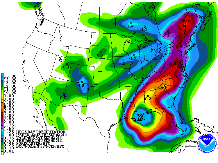
EDIT: I think the rainfall threat of 6-10 should be extended east into North Georgia Mtns./Western NC, rainfall amounts will most likely be enhanced in those areas as it usually is in mountainous elevations.

Btw, Texas is not playing fair w/ other drought stricken states that need Lee's rain by choking it off with that pesky dry air... <_<

If this map were to verify, the part of GA that needs the rain the most is the area that gets screwed backwards out of it (sighs) :itsok:


3119
Hurricane Central / Re: Tropical Storm Lee
« on: September 02, 2011, 05:04:36 PM »
Up to 45 mph  - 5PM Advisory


TWC's current forecast for the SE on Lee
Threat Level


Rainfall Forecast (I'm right on the edge of 6-10 inches)


3120
Everything Else TWC / Re: Blooper Thread
« on: September 02, 2011, 03:58:12 PM »
Logo is being displayed throughout the commercials.

EDIT: And during an emergency satellite local forecast

Pages: 1 ... 206 207 [208] 209 210 ... 470