April 30, 2026, 07:09:55 AM

Show Posts

This section allows you to view all posts made by this member. Note that you can only see posts made in areas you currently have access to.


Messages - TWCToday

Pages: 1 ... 235 236 [237] 238 239 ... 401
3541
Your Local Weather / Re: Norfolk and the Hampton Roads Area
« on: January 30, 2010, 07:02:32 PM »
Quote
Winter Storm Warning
URGENT - WINTER WEATHER MESSAGE
NATIONAL WEATHER SERVICE WAKEFIELD VA
404 PM EST SAT JAN 30 2010

NCZ012>017-030>032-102-VAZ065-079-087>089-091>098-100-310515-
/O.CON.KAKQ.WS.W.0001.000000T0000Z-100131T0600Z/
NORTHAMPTON NC-HERTFORD-GATES-PASQUOTANK-CAMDEN-INLAND CURRITUCK-
BERTIE-CHOWAN-PERQUIMANS-OUTER BANKS CURRITUCK-MECKLENBURG-
BRUNSWICK-GREENSVILLE-SUSSEX-SURRY-YORK-SOUTHAMPTON-ISLE OF WIGHT-
NEWPORT NEWS/HAMPTON-NORFOLK/PORTSMOUTH-SUFFOLK-CHESAPEAKE-
VIRGINIA BEACH-NORTHAMPTON VA-
INCLUDING THE CITIES OF...MARGARETTSVILLE...AHOSKIE...
ELIZABETH CITY...EDENTON...COROLLA...SOUTH HILL...LAWRENCEVILLE...
EMPORIA...WAKEFIELD...POQUOSON...FRANKLIN...NEWPORT NEWS...
HAMPTON...EASTVILLE
404 PM EST SAT JAN 30 2010

...WINTER STORM WARNING REMAINS IN EFFECT UNTIL 1 AM EST SUNDAY...

A WINTER STORM WARNING REMAINS IN EFFECT UNTIL 1 AM EST SUNDAY.

LOW PRESSURE CONTINUES TO DEVELOP OF THE NORTH CAROLINA COAST AND
IT WILL MOVE NORTHEAST AWAY FROM THE COAST OVERNIGHT. THIS WILL
CARRY THE MAIN AREA OF PRECIPITATION AWAY FROM THE COAST THIS
AFTERNOON. SOME WARMER AIR BOTH ALOFT AND AT THE SURFACE IN
EASTERN NORTH CAROLINA...HAS CHANGED THE PRECIPITATION OVER TO
A SNOW SLEET MIX...AND EVEN STRAIGHT RAIN IN ELIZABETH CITY. BUT
AS THE LOW PULLS AWAY FROM THE COAST...THE COLDER AIR WILL SPILL
BACK INTO THE REGION AND WITH AN UPPER LEVEL DISTURBANCE TO MOVE
THROUGH TONIGHT...SOME ADDITIONAL LIGHT SNOW IS POSSIBLE. THIS
COULD AGAIN CAUSE ROADS TO BECOME ICY...ESPECIALLY THOSE THAT ARE
UNTREATED.

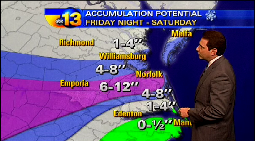
TOTAL SNOWFALL ACCUMULATIONS BY SUNDAY MORNING WILL AVERAGE 8 TO
14 INCHES NORTH AND WEST OF A LINE FROM EMPORIA TO WAKEFIELD AND
WILLIAMSBURG. SOUTH AND EAST OF THIS LINE LESSER SNOW TOTALS OF 5
TO 10 ARE EXPECTED. NEAR ALBEMARLE SOUND SNOW ACCUMULATIONS OF 4
TO 8 INCHES ARE EXPECTED.

CONTINUE TO MONITOR THE LATEST FORECASTS AND STATEMENTS REGARDING
THIS DEVELOPING WEATHER SITUATION.

PRECAUTIONARY/PREPAREDNESS ACTIONS... A WINTER STORM WARNING IS
ISSUED WHEN SEVERE WINTER WEATHER IS EXPECTED TO OCCUR. HEAVY
SNOW AND/OR SLEET AND ICE ARE FORECAST TO ACCUMULATE IN THE
AFFECTED AREAS CAUSING HAZARDOUS DRIVING CONDITIONS. THOSE WITH
TRAVEL PLANS IN THE WARNING AREA ARE ADVISED TO CHOOSE AN
ALTERNATE ROUTE... OR SHOULD USE EXTREME CAUTION IF TRAVEL IS
UNAVOIDABLE

3542
General Weather Chat / Re: Southern Snow
« on: January 30, 2010, 07:01:43 PM »
8in of snow today. lots of ice and sleet

3543
General Discussion / Re: The Pot Belly Stove
« on: January 30, 2010, 07:00:05 PM »
Good to see you again :)

3544
General Discussion / Re: The Pot Belly Stove
« on: January 30, 2010, 05:50:59 AM »
Whoo

3545
General Discussion / Re: The Pot Belly Stove
« on: January 29, 2010, 05:22:47 PM »
Is it me...or did Comcast boost up their internet speeds recently?
Here we have a 50/10 package, it's quite expensive but I love the speed, haha.
Thats what I want

3546
General Weather Chat / Re: Southern Snow
« on: January 29, 2010, 04:22:38 PM »
Tonight: Snow, mainly after 2am. Low around 26. North wind between 8 and 14 mph. Chance of precipitation is 80%. Total nighttime snow accumulation of 2 to 4 inches possible.

Saturday: Snow. The snow could be heavy at times. High near 30. Blustery, with a northeast wind between 15 and 22 mph, with gusts as high as 33 mph. Chance of precipitation is 100%. New snow accumulation of 6 to 10 inches possible.

Saturday Night: Snow, mainly before midnight. Low around 24. Blustery, with a north wind between 17 and 23 mph, with gusts as high as 34 mph. Chance of precipitation is 80%. New snow accumulation of 3 to 5 inches possible.

3547
Everything Else TWC / Re: General TWC Discussion
« on: January 29, 2010, 01:26:05 AM »
Brian pointed this out to me. Why is the green TWC logo being overlapped with the regular logo on the HD feel? You can see the outline just barely

3548
Everything Else TWC / Re: General TWC Discussion
« on: January 28, 2010, 11:57:52 PM »
wtf....Heather Tesch on Weather Center..... :blink:

Our former YWT duo are together again  :happy: , but it's kinda odd to see Heather on this late......
Indeed but she did great! Enjoyed it

3549
General Discussion / Re: The Pot Belly Stove
« on: January 28, 2010, 09:39:22 PM »

3550
General Weather Chat / Re: Southern Snow
« on: January 28, 2010, 12:27:12 PM »

3551
Everything Else TWC / Re: General TWC Discussion
« on: January 28, 2010, 02:31:12 AM »
Nicole mentioned in her facebook that she is going to be solo tonight on WCWC. Paul is in for Jim/Chris right now.
Chris is headed to Oklahoma City to start live shots

3552
General Weather Chat / Re: What's the weather in your area?
« on: January 28, 2010, 02:30:10 AM »
33F Clear

3553
General Weather Chat / Re: Southern Snow
« on: January 28, 2010, 02:27:55 AM »
Quote
A WINTER STORM IS EXPECTED TO EFFECT MUCH OF THE MID ATLANTIC
REGION FROM FRIDAY NIGHT THROUGH SATURDAY. AT THIS POINT...BASED
ON THE CURRENT PROJECTED STORM TRACK...THIS SYSTEM WILL HAVE THE
POTENTIAL TO PRODUCE SIGNIFICANT SNOWFALL ACCUMULATIONS...BETWEEN
3 AND 10 INCHES...ACROSS SOUTH CENTRAL AND SOUTHEASTERN VIRGINIA...
AS WELL AS NORTHEASTERN NORTH CAROLINA...WITH THE HIGHEST AMOUNTS
EXPECTED AWAY FROM THE COAST NEAR THE VIRGINIA...NORTH CAROLINA
BORDER...WHICH INCLUDES FRANKLIN AND EMPORIA. AT THIS TIME...IT
APPEARS THE LOWEST AMOUNTS WILL BE ACROSS PORTIONS OF NORTHEAST
NORTH CAROLINA NEAR THE ATLANTIC COAST AND ALBEMARLE SOUND...WHERE
SOME MIXING WITH RAIN OR SLEET IS ANTICIPATED.


3554
General Discussion / Re: Happy Birthday Tyler!
« on: January 28, 2010, 12:55:22 AM »
Happy Birthday :)

3555
General Weather Chat / Re: Southern Snow
« on: January 27, 2010, 09:12:40 PM »
Big hit for my region if it verifies

Pages: 1 ... 235 236 [237] 238 239 ... 401