November 23, 2024, 10:37:24 AM

Show Posts

This section allows you to view all posts made by this member. Note that you can only see posts made in areas you currently have access to.


Messages - Kevin K

Pages: [1]
1
TWC and your Cable Company / Re: Cable Boxes
« on: August 28, 2010, 08:39:23 PM »
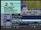
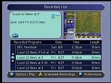
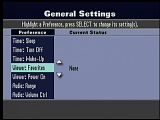
Here's a picture of the 8540 and some of the screens. I get the same blue Atlanta Scientific boot screen in the above posts.


This is exactly the same screens I have on my box. I agree it looks like something out of the 80s, not 2010.

Also, my box takes just as long as billy's to boot up. I dont understand why motorla's boxes can boot up in about 30 seconds but these take so long.

2
TWC and your Cable Company / Re: Cable Boxes
« on: August 26, 2010, 12:17:29 PM »
I have a Scientific Atlanta 4250 HD box from Cablevision. It sucks. It is very slow and you have to be careful not to change the channel or enter the channel numbers too quickly because the box will freeze up.

3
WeatherSTAR Tech Support / Re: Cablevision STARS
« on: July 09, 2010, 03:02:50 PM »
Bumping is not necessary as the STAR team usually views every requests and comments if time is available

I understand, I sure they have read it and I know that they probably busy, but since its been over a week, I figured they may have forgotten.

4
WeatherSTAR Tech Support / Re: Cablevision STARS
« on: July 08, 2010, 03:43:17 PM »
Really hate to bump this up, but could you please look into this and let me know what you think of my suggestions.

Thanks.

5
Your Local Weather / Re: Philadelphia weather
« on: July 06, 2010, 08:13:03 PM »
Thanks Mike! I enjoyed the lf clips. Also gald you got the clips of Nick Walker going over the records, I happened to have TWC on at that time too. However, I did not record anything.

6
Your Local Weather / Re: Philadelphia weather
« on: July 06, 2010, 04:57:49 PM »
Today is the hottest day of the year thus far. Many locations across the region are over the 100 degree mark right now. However, we have been lucky so far in this heat wave as the humidity levels have been low. Today the humidity has raised somewhat, but still in Philadelphia and most of the area, there is little or no effect on the heat index. This is going to change tomorrow.

I may post official numbers later, but for now I can tell you that Philadelphia definitely has broke its record, reaching at least 102°. The old record of 98° was last reached in 1999 during a heat wave that I remember well. I know other records were broken today, especially here in the New York area including Central Park breaking 100 for the first time in almost a decade. Perhaps Paul and I will collaborate to make a complete list to post here later.

Stay cool and stay inside if you can for the next few days. Hopefully temperatures will return to more normal levels by this weekend.

PHILADELPHIA
Weather conditions from Philadelphia International Airport as of 3:54 PM Eastern Time

Mostly Clear
Temperature: 102°
Wind: from the WSW at 13 MPH, gusting to 17 MPH
Relative Humidity: 24%
Dew Point: 59°
Visibility: 10 miles
Ceiling: Unlimited
Barometric Pressure: 29.98 in. (falling)


OTHER REGIONAL OBSERVATIONS...

Northeast Philadelphia Airport
103° Clear
Heat Index: 104°

Voorhees, NJ
100° Mostly Clear
Heat Index: 107°

Willow Grove, PA
99° Partly Cloudy
Heat Index: 98°

Blue Bell, PA
100° Partly Cloudy
Heat Index: 101°

Doylestown, PA
98° Mostly Cloudy
Heat Index: 99°

Quakertown, PA
98° Clear

Chester, PA
104° Partly Cloudy

Drexel Hill, PA
100° Partly Cloudy
Heat Index: 107°

Villanova, PA
98° Clear
Heat Index: 96°

Pottstown, PA
102° Sky Condition Not Available

Phoenixville, PA
104° Clear
Heat Index: 106°

Malvern, PA
101° Clear
Heat Index: 102°

West Chester, PA
99° Clear
Heat Index: 98°

Coatesville, PA
96° Clear
Heat Index: 94°

Reading, PA
101° Sky Condition Not Available
Heat Index: 100°

Lancaster, PA
99° Clear
Heat Index: 97°

Wilmington, DE
101° Clear
Heat Index: 100°

Allentown, PA
100° Partly Cloudy
Heat Index: 101°

Trenton, NJ
100° Clear
Heat Index: 101°

Mount Holly, NJ
100° Clear
Heat Index: 99°

Wrightstown, NJ
103° Clear
Heat Index: 104°


EXCESSIVE HEAT WARNING...
NATIONAL WEATHER SERVICE MOUNT HOLLY NJ
404 PM EDT TUE JUL 6 2010

An excessive heat warning remains in effect until 8 pm EDT Wednesday for the Philadelphia Wilmington metro corridor.

Record breaking high temperatures...over 15 degrees above normal...with values just over 100 degrees...will slowly ease back through the 90s this evening.

Temperatures Wednesday afternoon will approach 100 degrees and likely exceed the 98 degree record for the date.

While it probably will be 2-4 degrees cooler than it was today...higher humidity could compensate and result in heat indices just as hot as those of this past Tuesday afternoon.

Record or near record warm nighttime lows are forecast for the urban centers. Low temperatures early Wednesday in the city of Philadelphia may remain just above 80.

Prepare to adjust once again to the excessive heat on Wednesday. Our patience in this heat wave will help others cope.

The excessive heat should ease on Thursday as the onshore flow increases and the hot ridge of high pressure shifts westward. It will remain quite humid and the 90 degree heat wave will likely
Continue into Friday.

Considerable cloudiness along with scattered showers and thunderstorms should break the heat Saturday. A more comfortable Sunday is upcoming as low pressure and a cool front push out offshore.

Precautionary/preparedness actions...

The prolonged spell of very hot and increasingly humid weather will create a dangerous situation.

Avoid spending much time outdoors during the heat of the day and remain in an air conditioned location... If possible.

Be sure to check on your elderly relatives and neighbors.

Coaches... Trainers... Camp counselors and lifeguards should remain alert for signs of heat exhaustion and or heat stroke. It will be so hot this afternoon that the weather could affect anyone no matter their age or overall health. Please consider postponing any strenuous activities or work outs.

Keep your pets in a cool location and provide them with plenty of  water.


FORECAST FOR PHILADELPHIA (courtesy of the National Weather Service)...

TonightWidespread haze after 5am. Mostly clear, with a low around 79. West wind between 5 and 8 mph.

Wednesday
Widespread haze before 8am. Sunny and hot, with a high near 100. Heat index values as high as 104. North northeast wind around 9 mph. .

Wednesday Night
Partly cloudy, with a low around 77. South wind between 3 and 7 mph.

Thursday
A chance of showers and thunderstorms, mainly between 2pm and 5pm. Partly cloudy, with a high near 94. East southeast wind between 5 and 7 mph. Chance of precipitation is 30%. New rainfall amounts of less than a tenth of an inch, except higher amounts possible in thunderstorms.

7
Local Forecast / Re: Narrations on the HD STAR
« on: July 02, 2010, 03:22:48 AM »
Will the functions ofthe new HD STAR be more similiar to the current IS or will it be based off the regional HD forecast I have now with Cablevision? I hope it is not like the regional forecast we have now, the IS is what keeps me watching the SD channel instead of HD right now.

8
WeatherSTAR Tech Support / Cablevision STARS
« on: July 02, 2010, 02:35:06 AM »
Hi STAR Team,

I recently moved back to north jersey (after graduating college) and when I signed up with Cablevision I discovered my STAR has been changed. I'm guessing merged with other systems since it also has a different ID.

My primary CC used to be Teterboro but it is now Newark. While Newark is an important city and is most likely served by this STAR, Cablevision doesn't provide service to most of the towns surrounding Newark (here is a map of cable franchises in NJ to verify- http://www.cablenj.org/files/10_FranchiseMap3-4-10.pdf). For this reason, I would strongly recommend that the primary CC be in either Bergen or Passaic county, with Newark retained as a secondary city on the LDL. Also, Linden needs to be removed since it is served by Comcast. I am suggesting that Hackensack be the primary CC with Newark and Wayne as secondary sites. I also suggested other observation cities to be listed during the lf since most of them now are just repeats of what is already on the metro map (see below).

I actually like the new map better than the old one since I've always thought the old map covered too large an area. The STAR Team really did a great job with it except one small detail. Montclair is not positioned correctly and cannot be without making some other changes. I think the easiest way to fix this would be to removed Montclair and replace it with Parsippany.

Here is a summary of my suggestions:

Cablevision
Ch. 62
ID: 23228

LDL: Hackensack (primary), Newark, Wayne
 
8 Cities List: Bayonne, Bergenfield, Clifton, Hoboken, Oakland, Old Tappan, Paramus, Ramsey
 
Forecast: Change to Hackensack
 
Map: Remove Montclair and add Parsippany

Also would like to make a request for another STAR. This one is also Cablevision's and serves Central Jersey. Unfortunately I do not know the ID, but it is the one that serves New Brunswick and the surrounding area. Currently the three LDL sites are Piscataway, Somerville, and the Meadowlands. I would suggest changing the primary site to New Brunswick since it is a city and Piscataway is a suburban town. Somerville is a good choice and should stay. However, I do have to ask what you guys were thinking when you chose the Meadowlands for this STAR. The Meadowlands are in North Jersey (more specifically Bergen County) and certainly not served by this STAR, I would suggest changing it Old Bridge instead.

I would really appreciate it if you could make these changes.

Thanks,
Kevin
Pages: [1]