Hi, Jesse! A front is simply the boundary between two different air masses. For example, a cold and dry air mass coming from Canada could clash into a warm and moist air mass coming from the Gulf of Mexico, which happens very often over the Central Plains. Where the two air masses literally clash at each other is the front.
Now, the difference between a cold front and a warm front is determined by which air mass is winning the battle at the front. A cold front means that the cold air is literally forcing the warm air upwards like a plow. The cold air would be advancing forward in this case, and it would look like this picture:

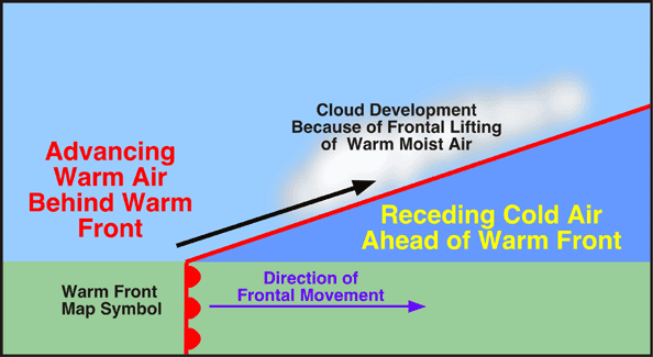
In a warm front, the warm air is advancing forward as it's forcing the cold air backward, and it would look like this picture:

Another key difference between the two fronts pertains to the steepness and strength. Cold fronts are steeper going up in the vertical and stronger than warm fronts. It's far more effective for the heavier cold air to plow up the lighter warm air rather than the other way around where the warm air is trying to push the cold air back. In both cold and warm fronts, the lighter warm air with its moisture is forced upward to create clouds and precipitation. The steeper slope of a cold front allows for greater rising motion and heavier precipitation than a warm front.
There's your quick lesson on fronts. There is more to this topic than what you see here as there can be more than two air masses involved, and there are also special situations that allow for two other kinds of fronts. Hope this helps, Jesse!

Note: The two images above come from a nice e-book by PhysicalGeography.net